
Feral Sierra High Route: A Spirit-Quest
Forrest McCarthy - 2009 Alaska Wilderness Classic
“…total utter euphoric suffering…”
Over the past few years, my summers have usually revolved around what I like to call a 'spirit quest.' These quests often involve long traverses made more difficult by my own unreasonable grandiose ideas. This summer will be no different, and I will be undertaking my biggest challenge yet - a solo attempt of Roper’s Sierra High Route and a portion of the Southern Sierra High Route
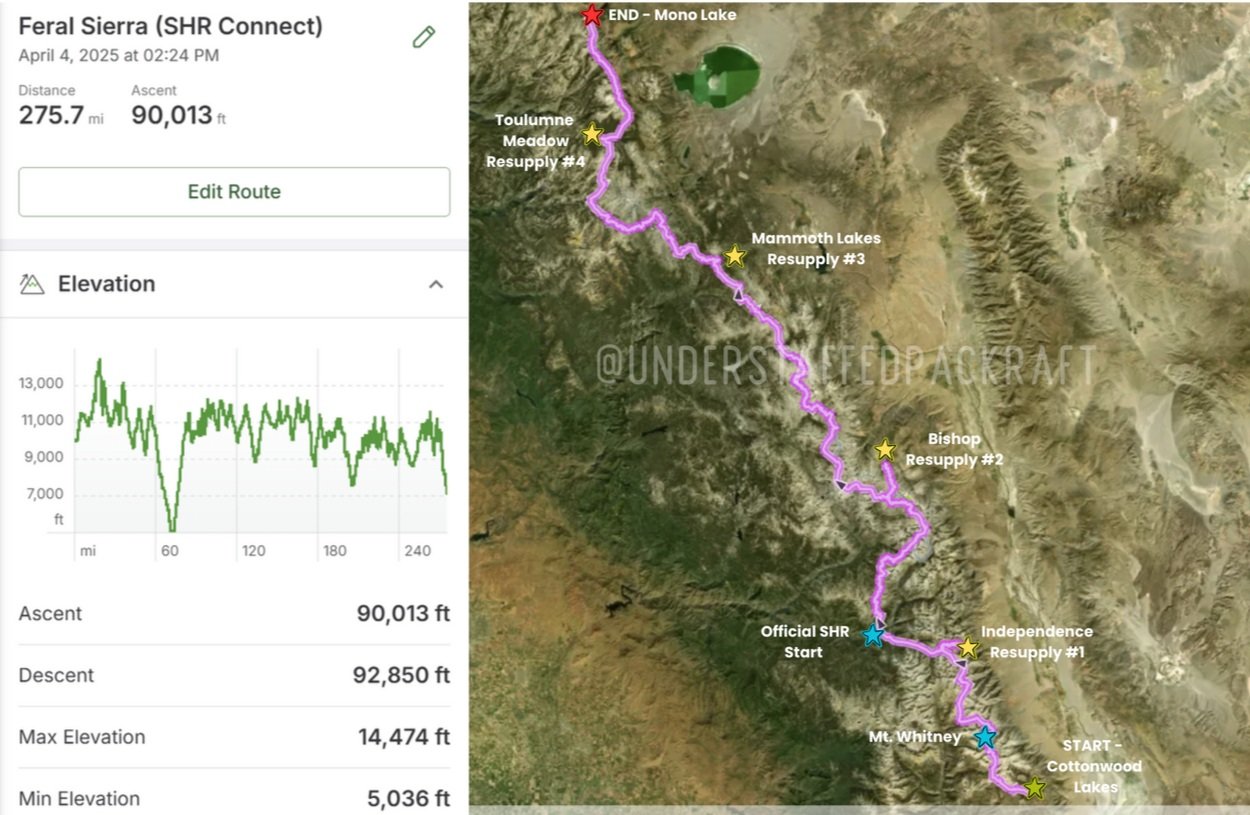
Total Miles +/- 275
What is the Feral Sierra High Route?
This route is a combination of:
Roper’s Sierra High Route
The Sierra High Route is a 195-mile, mostly off-trail traverse through California’s High Sierra, designed by Steve Roper to follow the remote and rugged timberline zone between Kings Canyon and Yosemite. It traverses over 33 named passes in the high Sierra, 70% off trail, totaling over 65,000ft of elevation gain. This route is largely coveted as one of the most difficult off-trail “thru-hikes” North America. Combined with the modified Southern Sierra High Route, I will be totaling around 90K of vert in 23 days!
Modified Dixon’s Southern Sierra High Route
Why am I not calling this a true “Super Sierra High Route Attempt”? I’ll be skipping about 30 miles of the SSHR. Since I’ll be alone and going NOBO, I don’t think I want to descend the Mountaineer’s Route on Whitney (Class III) mostly because it’s literally a scree shoot and with so many people coming up that way in the middle of July, I don’t need to be kicking rocks down or waiting on groups. Even though it adds about 5 miles, I think I’ll probably bail off the backside and link back up to the trail that way. I will also miss the section from Independence to Bishop.
My Plan:
Part 1: Southern Sierra High Route to the Sierra High Route
The classic SoSHR is usually hiked from north to south, but for my trip, I’ll be starting at the southern terminus and heading north. Mount Whitney on Day 3 - WHEW! The plan is to start in the south at Cottonwood Lakes in Inyo National Forest. I will go NOBO on the SoSHR over Mount Whitney, to a resupply in Independence. From Independence, I’ll take the connector trail across to Road’s End (Sequioa/King’s Side) to the official start of the SHR.
Permit: Inyo National Forest
Phase 2: Sierra High Route to Mono Village (Northern Terminus)
Using Kearsage Pass, I will hike 20 miles west to the start of the SHR from Road’s End. Then, its on the high route and over 38 passes until Mono Lake. I will resupply an 3 more times: Bishop, Mammoth Lakes, and Tuolumne Meadows.
Permit: Sequioa & King’s Canyon National Park
How long will the ‘Feral Sierra High Route’ take?
+/- 23 Days
Some days on the SHR I don’t expect to go more than 8-10 miles, so I’m guessing about 23 days in total (1 built in zero). About 5 days to get to the true start of the Sierra High Route, which allows me to attempt Whitney, make gear changes if necessary, and see if I like the food I have packed for myself or I need to modify! Hopefully I’ll pick up speed as I go, but I don’t want to rush anything either.
Resupplies/Food on Trail
Because I need to be METICULOUS about my food weight, I will be mailing all resupplies complete. If I have time to grab fresh produce or cheese to walk out with, but my calories don’t count on it. For this trip, I’m carrying about 4,000kcals a day in 28oz! It’s a variety of homemade and purchased meals, snacks, and absolutely no bars! Bars are gross!
Independence (6 Days)
Bishop (6 Days)
Mammoth Lakes (4 Days)
Tuolumne Meadows ( 2.5 Days)
Biggest Concerns on Route
Mental Resiliency - My biggest concern on this trip is my mental fortitude. I feel confident in my navigation skills. I know I won’t be perfect and thats the best part about this route, there’s a lot of room for interpretation. I’m worried about the long days when I have only my big brain and its 1 brain cell to make all the navigation choices. And I am also worried about pushing myself too hard with unrealistic expectations I have imposed on myself.
The “Class 3 - Not for Me” Solo Navigation Mentality (see below)
Nutrition- My appetite if the first thing to go at any signs of fatigue on my body. I really struggle to eat sometimes. I have accomodated my food accordingly so I have options I can easy get down when I don’t feel like it. I know I’m going to conventionally “lose weight” on this trip, but I don’t want to be wrecked and I’m meticulously planning my food to avoid that.
Injury - Obviously, anyone’s concern. I will need to be very mindful of the ankles and knees!
A “Class 3- Not For Me” Solo Hiking Mentality
Don’t misinterpret this, there will be plenty of Class 3 to be had on the SHR and I’m stoked for it.
There are no heroes for taking extra risks, and when I am navigating alone and unsure which line to take, I will stay away from Class III at all costs. Why? Because I literally DO NOT need to be in Class 3 Sierra Granite (this would be considered Class 4 in Colorado) alone. Class 3 is flowly, Class 3 is exciting, Class 3 usually goes without too much work. Class 3 is where you get hurt because you are in that sweet, sweet middle ground between pushing yourself and still making progress.
Logistics

Parking my Vehicle:
To make my life easier, I’m doing everything from Bishop. I’m just going to leave it at long-term airport parking or possibly at Tuolumne.
Shuttles:
START - Eastside Sierra Shuttle to Cottonwood Pass
END - Grab Eastern Sierra Transit back to Bishop
Resupplies:
Independence
Bishop
Mammoth Lakes
Tuolumne Meadows
INVALUABLE BETA
ORIGINAL GUIDE: Sierra High Route - Allen Roper
ADDITIONAL GUIDE: Andrew Skurka // Adventurer, Guide, Speaker, Writer
BLOGS: